Lima, Peru (2-11-25. and 2-12-25)
Scott King and I are currently in Lima, Peru. We've flown here from the USA prior to starting an ocean cruise to Easter Island & French Polynesia in a few days (Sunday, 2-16-25). Our cruise ship will be the Regent Seven Seas Mariner, and we will be boarding the ship in Santiago (San Antonio), Chili. More on that later, but first a few words about our first few days in Lima.
Tuesday's flights (2-11-25) were uneventful for both Scott and me and we unexpectedly landed early within 2 minutes of each other at the Jorge Chávez International Airport in Lima. My flight started in Newark, NJ, then to Atlanta, GA, then to Lima, Peru. From Newark to Atlanta I flew on an Airbus A321neo twin-jet. From Atlanta to Lima I flew on an Airbus A350-900 twin jet, about a 6 1/2 hour flight.
The curious thing was the lady who sat next to me from Atlanta is from Peru but lives in Florida in the same town as my brother.
Our tour company picked us up at the airport and took us to the Hotel El Tambo 2. Pretty basic, only one hand towel and no Kleenex.
Wednesday morning (2-12-25) Scott and I had a good breakfast before the day's adventure. Our guide Vanessa, was fabulous and knew her archeology and history very well for a non-archeologist.
Later we went to the Santuario Arqueologico de Pachacamac (Archaeological Sanctuary of Pachacamac), an archaeological site in Peru that includes ruins and a museum. Pachacamac (pronounced something like puh-chack-uh-mack), is southeast of Lima, in the Valley of the Lurín River, which was really old like 5000 BC. Well, maybe that’s off a little as she talked about the civilizations in Northern Peru being among the 5 oldest in the world beginning then and predating even Egypt. The remarkable info about this is that it was the only one that survived for 3000 years without war She said because of hallucinogenic beer that kept them peaceful.
The site was mostly mounds covered in desert soil, it seems the structures were primarily adobe and fragile. After they were excavated and searched and studied they covered them up again to protect them. We did see a few partially uncovered. It was raining so I didn’t get a photo. Sorry.
The museum was about mostly the Incas who were the last of the line. There was beautiful pottery in the museum.
The photo of pottery below may represents the deity Pachacamac, believed to be the "Earth Maker" and a god of fire.
I also took a photo of an accounting system used in Peru that relied on various colored strings and knots called a quipu (pronounced "kee-poo") and was primarily used by the Inca civilization to record information like census data, tribute collections, and inventory, with different colors, knot positions, and knot types representing different values and categories.
Fascinating that they could keep track of crops, cattle, etc with this accounting system.
 |
| Above: Peru accounting system |
Below is a photo of the knots that all mean something. |
| Above: Knots in Peru accounting system |
Below is another interesting pottery.
There was one edifice that had been reconstructed before the law was passed not to do that anymore. It was the House of the Virgins of the Sun. They had luxurious lifestyles until they were sacrificed by cutting their jugular. The chief probably drank their blood as well as the blood of boys who were also sacrificed for other reasons. The chief's house and the Temple to the Sun were semi-covered, and too far away to walk in the sand and rain.  The chief's residence had a huge patio with views of the ocean. It's good to be King.
After our visit to the Pachacamac site we came back to the part of the city that is called Barranco. It was originally summer homes by the ocean and later became an artsy area with galleries and studios. It's where they have an annual art walk with over 85 stops to be seen in a week.
We went to several beautiful galleries and a couple of them were in lovely old homes. And to an outdoor fair. There was a lot of truly original artwork and pottery and a lot of highly predictable. I always feel strange taking photos of other people's art so I only snuck in a couple of shots.
Below is a photo of a painting on long strips of wood that I thought was an interesting idea, shades of Louise Nevelson without the black or white.
And also a photo of a small piece of pottery that Scott called creepy.
Then back to Hotel El Tambo for a nap and out to dinner for ceviche (seafood, and sounds like suh-vee-shay) and a pisco sour, a type of brandy, the national spirit of Peru.
Tomorrow is the trip to the Nazca lines. Oh boy!
Touring the Nazca Lines (Thursday, 2-13-25)
Early in the morning, Scott and I were picked up at our hotel and taken to the Lima bus station. From there, we boarded a bus heading south along the Peruvian coast towards Paracas, a long drive of about 4 hours. Once at the Paracas bus station, we then transferred to the Pisco Airport for a one-and-a-half-hour flight over the desert to view the enigmatic Nazca Lines.
From the air, we saw gigantic figures, and mysterious patterns. The Nazca lines were hard to see, not enough contrast, but below is a map I photographed.
Lots of theories of why these lines are here (lines of irrigation or point to water sources, religious/social significance, etc.), but nobody really knows for sure. Below are 3 of the actual photos I did take.
A spiral below, the clearest we saw.
The following photo shows the huge airport with no one there but staff pilots and 8 folks getting off the plane and few getting on. In the USA we call that “pork.” We wondered what deal was made to spend the funds in that congressman’s district.
The next photo shows the Cessna Caravan plane we flew in over the Nazca Lines.The last photo shows some Not-Nazca Lines. :o)For all you folks out there that love airplanes, attached is a photo I found on the Internet of the fleet of Cessna Grand Caravan airplanes that were used on these flights. A good airplane for trips like this, lots of window spaces, and the planes had a good old Canadian Pratt & Whitney PT-6 turboprop engine. Each of these airplanes hold 12 passengers plus 2 pilots.
Traffic was so bad in Lima we didn’t get back in time to repack before hunger struck. We didn’t do much later after dinner at the Café de la Paz. We have a good life don’t we?!
Touring the Ballestas Islands in Peru (Friday, 2-14-25)
Friday morning Scott and I headed south from Lima to the El Chaco pier embarking on a one-and-a-half-hour boat tour to the Ballestas Islands, a group of small islands near the town of Paracas, a smallish town with expected tourist shops along the water's edge. It was a 3.5 hour bus ride south from Lima to Paracas in a cramped seat, but we made it as you can see in the following photo.
The next photo is of a water park in Paracas called Yakupark, it is the first water park we’ve ever seen using oceanfront water.
Our hotel was next door and had the longest pool we’ve ever seen. If you enlarge the following photo of the pool you can see me at the other end of the pool. It was a family place with lots of kids and honeymooners.
These islands are interesting shapes and holes and home to lots of wildlife. Called the Galapagos of Peru. Well, not so much. We saw a lot of sea lions and learned about them and their mating, etc., lots of birds. Some seasons have blue footed boobies or red footed boobies, but not this season. The following photo was/is a guano farm I guess you’d call it. Guano is excrement from birds very high in phosphorus I think and used in fertilizer.
Two months a year two guards are posted there to protect the wildlife from hunters. Not an exciting job I think. It was quite a pleasant trip after all the arid sand stuff.
During the tour, we also saw a drawing in the desert sand called the Candelabro, a well-known prehistoric geoglyph found on the northern face of the Paracas Peninsula. This was created thousands of years ago. pointing perfectly to the 4 directions.
After our tour the ride back to Lima was much nicer, somehow we got a luxury seat so ok. Back to Hotel El Tambo overnight then to the airport for our flight to Valparaiso, Chile. From Chile we will start our actual Easter Island & French Polynesia cruise, starting on the 16th of February. Actually Scott and I are on this cruise as you read this, but I will write on it later.
Traveling from Lima, Peru to Valparaiso, Chili (Saturday, 2-15-25)
Saturday afternoon Scott and I boarded an Airbus A321 in Lima and made a 3+ hour flight to Santiago, then bussed to Valparaiso. This was to prepare for our ocean cruise on Sunday (16th) to Easter Island and French Polynesia.
Some of you may recall that Scott and I were in Valparaiso in 2020 as part of our Patagonia-Antarctica cruise. At that time we stayed at the boutique Hotel Cirilo Armstrong, originally built as lofts to accommodate architects and engineers working in the port. Later they changed it to a hotel with only 11 rooms. This time Scott booked us into another unique place, a "green" hotel made of 25 recycled shipping containers, a place called Winebox, with only 21 rooms. It wasn't the cheapest hotel, but very curious, lots of bold colors and built on a sloping site, with great views.
Along with the 25 recycled shipping containers, the hotel consists of 3000 pallets, and 2000 wine bottles. Pallets, bathtubs, and container doors were used for tables, chairs, and much more. Plus Valparaiso is known for its murals. They abound in and around the hotel giving it a used and recycled appearance. It is quite comfortable and very open-air air feeling even though it was 59 degrees when we woke up this morning.
Supper and breakfast are on the open-air rooftop and served by really delightful young folks.
I didn’t get a photo of the outside of the Winebox 😞. a really funky place, but attached is one I lifted off the Internet.
Below are 3 photos that I took, showing the rooftop restaurant and our room (notice Scott in the back of our room). Also notice that some of the furniture on the rooftop is made out of old bathtubs.
A fun fact, Valparaiso is sometimes called Little San Francisco, or Pancho, a nickname for the name Francisco.
We go to the ship this afternoon.
Aboard the ship (Sunday, 2-16-25), at sea
Aboard the ship (Monday, 2-17-25), at sea
Tomorrow we port at Robinson Caruso Island. If the weather stays like this and the bay isn’t sheltered enough by the island we’ll be having another leisurely sea day.
Captain Abhi Singh has a sense of humor so his messages are worth listening to. Like when leaving port he said we will be backing out of the docking area hopefully not running into anything. We didn’t. I thought that was funny coming from the bridge.
We are going to the Captain’s cocktail party tonight just to hear him. They are usually boring, so very skippable.
Tuesday, 2-18-25, Robinson Crusoe Island, a few days after Scott and I started our cruise
Our cruise ship is the Regent Seven Seas Mariner as shown in the photo below I sticky-fingered from the Internet. Also shown is the location of our cabin.
The map below shows our intended port of calls, leaving from San Antonio, Chile with our final cruise stop at Fakarava in French Polynesia.
The first photo below was taken Tuesday at sunrise just as we were coming into Robinson Crusoe Island, the largest of the Juan Fernández Islands.
It seems Alexander Selkirk was marooned here from 1704-1709 and is believed to have inspired Daniel Defoe to write the classic novel of Robinson Crusoe. The island was first named Juan Fernandez Island after Juan Fernández, a Spanish sea captain and explorer who was the first to land there in 1574. It was also known as Más a Tierra (Closer to Land). In 1966 the Chilean government changed the name to Robinson Crusoe Island to reflect its status as the inspiration behind Daniel Defoe's most famous novel, and attract tourists.
The next photo shows the town, or half of it. We had to tender in on very rough water. The weather made landing questionable but we made it with a very rocky ride. Not much to say. They had a post office in a container and some other stores like minimarts. The residences we could see were all made of wood.
Below is the obligatory photo so you know I was here but it doesn’t make sense since the top of Robinson Crusoe's head got cut off. I had on gym clothes when we decided to go. Not my best look.
Following is one of the most beautiful trees I’ve seen lately.
The next photo shows a chicken that crossed the road, so I snapped the photo.
Later Scott and I went to the Botanical Garden. I’m not sure what the flower below is, but it’s beautiful.
About 900 people live on the island with an economy focused on the Spiny Lobster. The title on sign on the next photo translates to Juan Fernández and Desventuradas Islands Fishery Species and Resources.
Our next port of call will be Easter Island, but we won't arrive there until Sunday, the 23rd. From Robinson Crusoe Island to Easter Island we will be at sea for about four days.
At sea (Wednesday 2-19-25)
At sea (Thursday 2-20-25)
The first two photos show what we'd been seeing every morning while at sea, just clouds and waves. These photos were taken a few days after we left Robinson Crusoe Island.
Today the 20th so far I've learned 2 magic tricks. And on my way to a card creating class to be followed by a native handcrafting class followed by adult beverages I suppose Someone has to do it 🥴.
You might wonder about the next photo. Well Scott fell down and bruised his eye. Me? I was opening some “medicine" and the cork hit me in the eye.
At sea (Friday 2-21-25)
At sea (Saturday 2-22-25)
Arriving at Easter Island, Sunday, February 23, 2025
"Lorana," as they say on Easter Island. Lorana is used as a greeting, as well as a farewell.
Our first stop on Easter Island to see the statues (Moai) was at Ahu Akivi, these 7 Moai are different from most as they face the sea. Normally they face the village that had them carved to protect it. This Village is in ruins anyway. Ahu Akivi is located inland and It was pretty rainy as you can see from my view through the window of the bus that took us there.
The photo below is of the 7 Moai at Ahu Akivi.
A bit of explanation about the Moai. (the plural is also Moai) They were carved and put on a platform called an ahu in the community to honor the leader whose remains are buried under him. It is an elaborate process as the leaders are descendants of the first leader that came from Polynesia and are believed to have powers sort of godlike. They are believed to have mana or energy to protect the village. Most chiefs or leaders were descendants of the first king, then the next one etc. They are really big. Overall (not just this group) they range in size up to 10 meters high and can weigh more than 80 tons. I felt the power of the place.
All of the Moai were knocked down either intentionally by warring with nearby communities or by natural causes. The ones that fell face first were desecrated by the former to dishonor them and the collapse of the platforms for the later. What is now standing has been re-erected and repaired by archeologists from various institutions from around the world. What is known about them is through this research and is still mostly a mystery.
The island has had many troubles. The Rapa Nui civilization (the first people to settle on Easter Island, which they named Rapa Nui) came from Polynesia, perhaps as early as the 700's and peaked in the 1400's or so it is thought. There was an overpopulation problem at one point and most of them died, in the 1860's when raiders and traders came and enslaved all but 111 of the islanders. The Moai were damaged by the Tsunami that resulted from the 1960 earthquake in Chile and knocked down most of the Moai that had been resurrected so to speak. So, it is a lot of history to absorb and condense. By the way, it was named Easter Island by Jacob Roggeven when he discovered it on April 5, 1722, Easter Sunday.
The next stop was Ahu Tahai. The 5 Moai shown below are also carved in honor of the leaders, again their exact meaning remains a mystery despite the attempts of the archaeologist, William Mulloy, who was responsible for much of the restoration throughout the island.
The second of the two figures (shown below) adjacent to the five was very important because a researcher found evidence that the Moai had eyes, not just eye sockets. These eyes were made of coral and had obsidian pupils. None survived so these were replicas and others that we saw were not as believable.
Then as always you exit through the gift shop (see photo below). We didn't buy anything.
Below is a photo of a representative of the Moai for blind people, with a braille description on the side. I thought this was great.
It was an amazing day and we were glad to return to the ship (see photo below). This photo taken from inside our tender.
But just you wait and wonder, as we sail to the other side of Easter Island. Day #2 is even more amazing.
Easter Island, Anakena, Monday, February 24, 2025
There were 2-3 meter rolling swells making our ship to move to a temporary landing that was less than perfect and actually scary. The ship's captain did a daring maneuver using one tender as a landing platform and using 2 others to deliver us to shore. My first view of the Moai that I came to see is beyond the jetty where he tied the tender. After the harrowing transfer between waves to the attached tender we had to hike across the beach because the normal roads were too muddy for the buses to be near the landing.
Below is the jetty where they tied up the tender to land passengers.
Below is the view walking across the beach to the bus to take us to Rano Raraku Moai statue quarry where we saw lots of Moai statues.
Almost all Moai statues were carved here before being transported to other parts of the island. There are approximately 400 statues left at Rano Raraku. About half are finished and the rest were never completed.
The map below shows the location of Rano Raraku.
Below: The hillside was dotted with these partially finished Moai. I was gobsmacked.
Below, it’s hard to see but the one in the back is finished so he’s ready to travel to the Ahu, his pal needs more carving. Weather has affected them since 1400.
There were so many to see. I'm sure they won't miss one if I decide to bring one home for my apartment.
The ones below were partially done. They would dig out beneath them and fill in more stone to get them more and more upright.
Below is another handsome fellow. Who knows how tall he might be if they dug around him.
If you look carefully at the one below you can see the beginning of the carving for the biggest one ever, 15 meters tall.
Many of them were carved and then dug around to finish toward the bottom and then nature filled in around them.
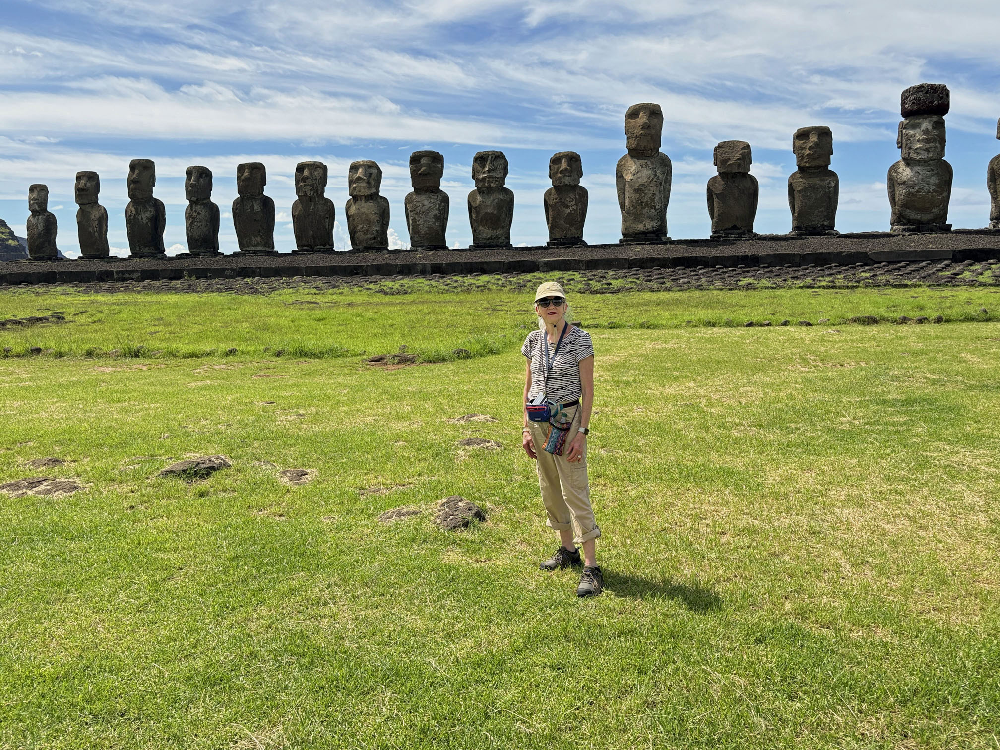
Ahu Tongariki, the 15 Moai statues - Monday, February 24, 2025
Ahu Tongariki is the iconic collection of 15 Moai representing 15 of the 16 tribes, with a space on the ahu for the 16th one if it is ever found. They are placed with their backs towards the ocean. See all my photos below.
These guys are ginormous, you can feel it when you look at the back of them. These Moai were washed 500 feet inland after the 1960 tsunami I mentioned in an earlier email. Many had to be restored again. That really big one was problematic because his head and shoulders weren’t flat and when they put his head on it was tilted. I’d like to see a picture of that. So with special permission they drilled into him to put steel reinforcing rods. The heads usually have a peg-like extension that fits into a slot on the body. The necks are the weakest point which is why so many of the fallen down ones are detached.
There is conjecture and theories but no real proof how they were transported. They were said to have walked. This is the best theory as it means the builders moved them like we move a refrigerator one side forward then the other. Keeping them upright would seem to me to be challenging. They had ropes made of banana tree strips I think I heard.
It was an enormous thrill to see all of these Moai, especially the last two stops. Many photo images of Moai you might see are better than mine because they were taken when the light was right. But… I’m good. Better said just great with what I got. The memory and impressions are more important than the photos.
There’s one more stop, Orono, which has no Moai but did have major petroglyphs which now live in England maybe.
Seeing the Easter Island Moai and the Nazca lines have been on my bucket list for a long time. I know a lot more now, and know there’s more to learn even though most of it is a mystery.


Easter Island, Motu Nui, the Birdman Ritual, near Orongo - Monday, February 24, 2025
This is a ceremonial site from many years later than the other sites. It was from about the 1800’s and was the move from nepotism to more of a democracy. It is called the Birman phase.
The ritual took place once a year to determine who would lead the village for the following year. First a group of virgins were selected and taken to live away from the village and were not allowed to go out except at night. The theory our guide suggested was to keep their skin from getting dark as they believed pale skin was a sign of nobility.
Then each tribal chief selected a young man to be in the Bird Man competition. His assignment was to climb down the cliff, swim to the nesting island (Motu Nui), the largest one in the photo below, and wait for the migratory birds to come to nest.
The swimmer that got the first egg was the Bird Man. He gave his egg to his tribal leader who became the chief for the year.
The swimmer then got to choose which virgin he wanted to marry. The used narrow planks and paddled out floating on them. They sometimes had to wait weeks for the birds to come and lay eggs and sometimes they missed it all together
The people lived in these low stone houses with grass roofs for the duration of this process.
The area is behind the volcano Rano Kau, one of the 3 major volcanic craters that form the island. You can see the ocean behind the rim of the crater in the photo below.
Fun fact. The tallest crater gives you a full 360 degree view of the sky, the ocean , and the island. They say it’s the only place in the world to see both land and sea 360 degrees.
Tuesday, February 25, 2025: A sea day.
Our ship left Easter Island this morning.
Wednesday, February 26, 2025: A sea day.
Thursday, February 27, 2025: Sailing by Pitcairn Island.
A few comments and photos about one of our sea days between Easter Island and French Polynesia, when we sailed close to Pitcairn Island, on Thursday, February 27, 2025.
The first photo is our first view of Pitcairn Island.
The following photo is the islanders coming to our ship to give us a talk about their life. There are 37 residents on an island 2 miles long and 1 mile wide.
The next photo is a closeup of Bounty Bay where Fletcher Christian and the mutineers burned the Bounty so they couldn’t be found. As you no doubt recall, Fletcher Christian led a mutiny against Captain William Bligh on the HMS Bounty in 1789.
Next photo is a view of the entire island.
Then a photo of a photo of the residents.
A Council woman gave us a fascinating talk. She talked about life as a community. dealing with England as they are a British Overseas Territory, getting supplies from New Zealand. They all have solar panels for power and Starlink for WiFi. It is a curious history with the British seamen, the Polynesian men and women.
Some interesting info. When supplies come every 3 months, they take the long boats to the cargo boat to bring the goods ashore. That barge also brings passengers at another time. If you want to go for a holiday you can book a home stay for varying lengths of time depending on the barge schedule. I can give you the website if any of you are interested.
They have a church, market, clinic, marine science lab, a school, but no students. Their biggest problem is they need people, young people as the average age is over 50.
The above photos are all the photos I made, but I found some additional photos made that day of our ship by someone from the island and posted on a facebook site called Pitkern Islen Enterprises, apparently a business that sells honey and bee products from Pitcairn Island. That post was titled "Seven Seas Mariner visits Pitcairn, February 27, 2025." I'm adding a few of their photos below as they are interesting to me.
Friday, February 28, 2025: A sea day.
Sunday, March 02, 2025: Fakarava Island.
Scott and I arrived in French Polynesia on the island of Fakarava Sunday morning the 2nd of March. Fakarava is the 2nd largest atoll in Polynesia and it is known for having two passes: the Garuae Pass in the north, which is considered the largest pass in French Polynesia, and the Tumakohua Pass in the south. The local tourist office was proud to tell us it had the 2nd largest pass as well.
This atoll is well-known for its beautiful coral reefs, abundant marine life, and pristine seas. It is a UNESCO Biosphere Reserve. Fakarava is of course owned by France.
The first photo below shows the first thing I saw when we landed in French Polynesia. It cracked me up, a gas station in a tiny village with one road, a grocery store closed because it was Sunday. Along the road there were two shops and palm trees, breadfruit trees, and Assyrian pumpkin trees. That’s it folks beautiful trees and of course the beautiful sea.
In the next photo I have no clues what this sign says but it was the second thing I saw when we tendered in. So I thought it was welcome to Fakarava. Well, maybe not.
Scott and I took a short walking tour and below are a few photos.
In the photo below, what was interesting to me was they have a huge black tipped shark community and you can swim with them as they are not aggressive. I didn’t. You see the depth of my engagement with the surf.
Monday, March 03, 2025: Huahine Island.
Another beautiful day in paradise.
Huahine is another island in French Polynesia, the second stop of the 5 islands Scott and I will visit in French Polynesia. Huahine actually consists of two islands - Huahine Nui (Big Huahine) in the North and Huahine Iti (Small Huahine) in the South. The two islands have a total population of around about 6,000 to 8,000 people, depending on which source you believe. The bulk of the island’s population is of Polynesian ancestry, and they speak Tahitian and French.
In the photo below (taken in Moroe Bay, between the two islands) our ship's tenders lined up to take us to shore and our first glimpse of Huahine. Pronounced hoo a he ni. Very much like the Hawaiian 🌺 word we know, wahine meaning woman. (Consort to the big kahuna).
Ostensibly the archeologists found remains here from 850 AD. We didn’t see those. We thought we wanted to go to two botanical gardens. However our lorry ride (photo below) proved that the whole island was a botanical garden.
The 6 mile ride took us to the Main Street on Huahine Nui (Big Huahine) where there were the predictable souvenir stalls. I had an assignment from a friend to buy some non-French perfume. Nada, only French and not much of that, they use oils with herbs to repel mosquitoes 🦟 that also smell good and moisturize skin. I sniffed some. Nope.
Many passengers from our ship went snorkeling, but Scott and I didn’t because I got sun poisoning on Easter Island and am not going bare-skin exposed just yet.
In the photos below you can see the views were spectacular of sand, trees and sea.
This is a super gorgeous area of our planet and super warm. The feel-like temperature was 89F. So we explored the town a little bit. One shop was a combination of Ace Hardware and a souvenir shop with everything jumbled together. And another looked like a 7-11 from the outside and a small Walmart inside. Most everything except some souvenirs, beer, and bread were imported
The baguettes in the photo below were 65 local francs which is 65 US cents.
Later we watched an intense rain shower descend from the mountain to drench the ship with rain coming in at a 60 degree angle with the sun still shining resulting in a full arc rainbow that I couldn’t capture on my phone.
And below is a photo I took of the sunset, taken from the cruise ship.
Tuesday, March 04, 2025: Raiatea Island.
On Tuesday Scott and I were at the islands of Raiatea and Taha'a, two sister islands in French Polynesia. Both islands are part of the Society Islands in French Polynesia. They share the same lagoon, which can be accessed by boat between the two islands.
The first photo was taken at Taha’a on the Faaroa River & Motu Beach cruise, a boating excursion between Taha’a and Raiatea.
The next photo shows a photo of a policeman on Raiatea, with his “weapon.” Baguettes seem to be ubiquitous.
The next photo was taken in Faaroa Bay in Raiatea on our boat trip.
The following photo shows where we stopped at Motu Iriru, an islet off the coast of Raiatea. I was crowned with the local fresh handicraft. I look like someone out of Jane Eyre don’t I?
It was another feels-like 90F day so we only walked around the small town of Uturoa a little. Of course we went into the local Walmart, it was air conditioned. I learned that they pronounce most of the vowels so this is Rai a te a.
And of course there were chickens crossing the streets. Beautiful islands but not much to tell except it is surrounded by coral reef which protects it from tsunamis which they’ve never had. And they have no poisonous creepy crawlers and the plentiful mosquitoes are teeny and don’t carry malaria or dengue fever. After our walking tour we headed back to the ship for adult beverages and 3 course meals.
Wednesday, March 05, 2025: Moorea Island.
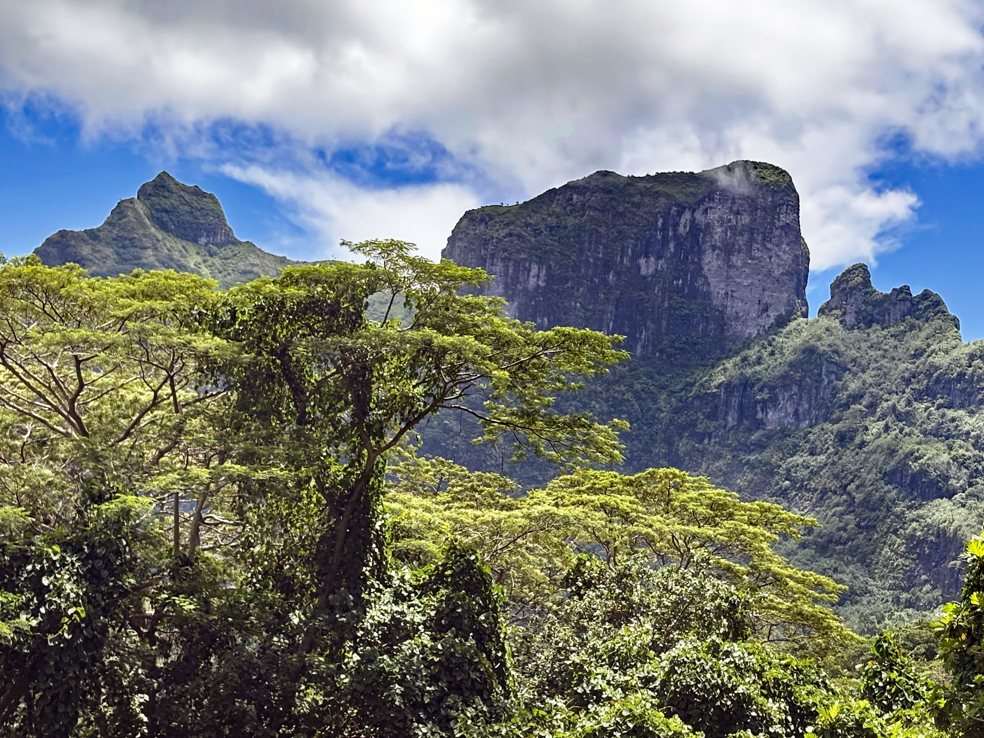
On Wednesday (03-05-25) Scott and I visited Moʻorea, also spelled Moorea, a volcanic island in French Polynesia, and our 4th island stop in French Polynesia.
The first photo shows a welcoming sign in Papetoai, a commune on the island of Moorea.
The next photo shows a typical musical greeting, almost everywhere were string players in colorful attire. The gender varied.
We went on an all day tour of the island. First stop was a sacred site called Marae Titiroa. The trees are chestnut trees and the chicken is holy. Maybe they say “holy chicken” here instead of “holy cow?”
Next stop, the highest place is called Belvédère Lookout.
On the way down the mountain we passed a pineapple field. All the area around the mountain is owned by the municipality so I’m confused about who farms the crop and who gets the revenue. The next photo is of a small pineapple field. They call this island the pineapple island. 🍍
Then back to Opunohu Bay where I took a photo of our ship and some beautiful palm trees. The highlight of the day to me was getting many many palm trees and sea shots. This was my reward after the expensive pearl shop. No photos of that but at least one of these 🌴 shots are from across the street from it. Back to the ship with a brief stop on the pier to look at local artisan stuff and then to pack. 🧳
My friend Monica said her husband David says "when the Polynesians sailed from island to island most of their consonants fell overboard, and ever since they have had to make do mostly with vowels." An example is the airport here, Fa'a'ā. Too funny!
Thursday, March 06, 2025: Tahiti Island, and Bora Bora Island.
When we left the island of Moorea our ship went to Papeete in Tahiti Thursday. We didn’t do anything special in Papeete, we went to the Faʻaʻā airport and took a flight to Bora Bora. See the following photo for the Air Tahiti ATR 72 Twin Turboprop plane we flew on. The ATR 72 is powered by a pair of Pratt & Whitney Canada turboprop engines. Back in my aerospace days I started out working for Pratt & Whitney in Florida, but not the Canada division,
The next photo is of a sign at the Bora Bora airport. The airport is not on the main island of Bora Bora, but on an atoll, or islet. The sign in the photo says “AEROPORT DE BORA BORA.”
Friday, March 07, 2025: Tahiti Island.
On Friday Scott and I were at Bora Bora, a small island northwest of Tahiti in French Polynesia. Last Tuesday (the 4th) when our cruise ship was off the eastern coast of Raiatea Island, we could see Bora Bora and I took the following photo of Bora Bora with the telephoto lens on my iPhone. You can see the unmistakable profile of the volcanic island.
From the Bora Bora airport we took a ferry (there's a ferry for each Air Tahiti flight) to the main part of Bora Bora, where the owner of our hotel picked us up. We were staying at the Rohotu Fare Lodge which is located on the mountain slope. We shopped for breakfast and lunch food and local beer, then went to our hotel accommodations.
The Rohotu Fare lodge is an act of love, patience and creativity. And I have a few photos to share from the hotel, First the bathroom. The shower is the black statue and the water comes from her hands. There is no ceiling so if it rains you get wet. 🥴 Then the sink in the middle.
A photo of the bed and the outstanding view from the porch.
Another photo from the hotel.
Yes, there is very comfortable air conditioning and two hand towels, but no Kleenex if you remember my complaint from Lima and Chile.
Later the host loaned us his car and we circumnavigated the island, a little more than 20 miles. Following are some shots of the vistas and the island.
A few additional comments. Unlike Moorea Island, none of the electrical or communication lines were buried in Bora Bora, which made some shots hard to get. We think maybe Moorea Island is more affluent because it is only 20 miles from Papeete and people commute from there as well as have weekend homes there. It also rained twice in the time it took to make the drive so some shots were pretty rushed.
We stopped back at the store to buy two more beers and then to the Aloe Cafe in Vaitape for lunch. Scott’s ceviche was amazing . I didn’t do a Facebook bit and photograph his lunch.
The other curious thing I learned Friday is that the Polynesians don’t have polite words like "excuse me" or "I’m sorry" or “please" in their vocabulary, and only a few will use the French equivalent.
I had flaming shrimp 🦐 for dinner (see photo below) at the Restaurant Saint James, a waterside restaurant with a spectacular view.
Saturday, March 9, 2025:
Scott and I were still in Bora Bora Saturday (8th). We kept it lazy…Polynesian way.
The Rohotu Fare Lodge where we are staying is a lush paradise of native plants and tiki carvings and Tahitian women statues. I love the tiki statues and the one in the photo below is in our bathroom. I took a dozen more photos but can’t send them all.
We drove to town to do a couple of errands including buying gas. $22 for a quarter tank on a Ford Fiesta! Never complain about gas prices to me.
The Mountain View in the photo below is from where we park the car.
I grew up on the most beautiful beach in the world (Clearwater, Florida) so other beaches are not usually a big deal for me. But I’ve never swum (or is it swimmed?) in the South Pacific Ocean, so we went to the famous Matira Beach for a swim, beautiful views and crystal clear water. See photos below of Matira Beach.
The beach was lovely, a little rocky getting in but refreshing. We are going out for Polynesian Happy Hour. I’ll let you know if it is different.
On the day of our departure from Bora Bora, the Tahitian sky’s sent me this beautiful full arch rainbow (photo below) to say goodbye.
Scott and I left the island of Bora Bora for Papeete, Tahiti only to have a 2 hour delay whereupon I found my own wings. See photo below.
Then we boarded the Air Tahiti ATR72 aircraft shown below, and arrived in Papeete, Tahiti.
After landing we walked to a nearby hotel, a comedown in accommodations.
Monday, March 10, 2025:
Monday morning early to the Fa'a'ā International Airport where I was finally able to buy a magnet for less than $10 and the ubiquitous flower for my hair (shown in the photo below). Na na French Polynesia.
BTW, boarding our flight to LA, the stairs on the Airbus A350-900 were maybe 6 feet from the front of the engine. I could take a photo but it was fun to see up close what I’d worked on in the beginning of my career as an engineer, an up close and personal view of a big jet engine. The engines on this aircraft were by Rolls-Royce. In my aerospace days I worked for the Allison Engine Company, which was later purchased by the Rolls Royce company after I left my engineering career.
We should arrive in LA around 8 pm, after about an 8-hour flight, on Delta Flight 8467


No comments:
Post a Comment